42% less crime, one map at a time.
A chief of police talks about how his team used geographic information systems (GIS) to map crime hotspots. By tackling those hotspots, his team has reduced crime volume by 42% and crime harm by 48%.
Watch Video
A chief of police talks about how his team used geographic information systems (GIS) to map crime hotspots. By tackling those hotspots, his team has reduced crime volume by 42% and crime harm by 48%.
Watch Video
In this episode of Getting Technical, explore the latest AI features in ArcGIS, including GeoAI, AI assistants, agentic workflows, Trusted AI and new developer tools.
Watch Video
Learn how police services are using GIS to operationalize hotspot policing. This webinar highlights real-world examples from Ottawa and Barrie Police, showing how spatial and temporal crime analysis s
Watch Video
Ingrid Buday of No More Noise Toronto built an urban noise reporting tool with ArcGIS Survey123. When people started using it, she saw she wasn’t alone. Now she has 12,000 data points and a movement.
Watch Video
In today’s GeoSnap, we walk you through how to use the Item Details assistant in ArcGIS Online and ArcGIS Enterprise to create higher-quality metadata.
Watch Video
AI assistants are now available across the ArcGIS ecosystem, empowering users with intuitive, conversational ways to work with their maps, data and tools. These capabilities open the door to faster in
Watch Video
Just getting started with ArcGIS Pro? Use these tips and strategies from certified ArcGIS instructor Oscar Andrade-Rios to guide your learning.
View
Batch Editing with the ArcGIS Web Editor and getting the most out of your editing workflows.
Watch Video
In this webinar, we’ll demonstrate the newest capabilities in ArcGIS Pro 3.5 and 3.6, focusing on practical workflows that make analysis, visualization and data management faster and more intuitive. W
Watch Video
Discover how Fathom Studio blends geographic information systems (GIS) and artificial intelligence (AI) to power better planning, improve decision‑making and shape the future of community design.
Watch Video
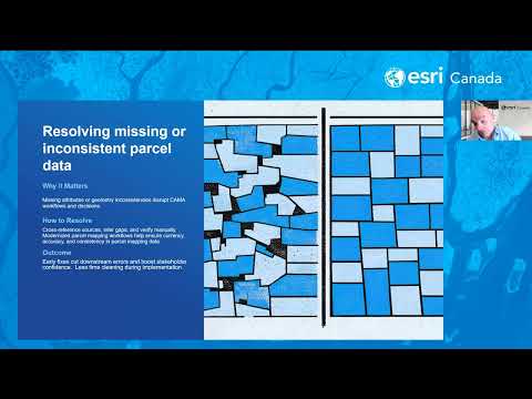
GIS managers can ensure a successful Computer Assisted Mass Appraisal (CAMA) migration by prioritizing deep data cleansing, establishing robust spatial validation and fostering cross-functional collab
Watch Video
Discover the latest updates in ArcGIS Hub, the ArcGIS Living Atlas of the World and ArcGIS for Microsoft. Stay ahead with new GIS tools and smarter workflows with this edition of Getting Technical. M
Watch Video
In this GeoSnap, you'll learn how to retrieve the data from your device if it didn’t properly sync in the field, & how to use ArcGIS Pro to sync or append it to your database once you return to office
Watch Video
Today, I’m going to show you how to make a map template in ArcGIS Field Maps. This will not only duplicate the map but also the data.
Watch Video
In today’s GeoSnap, we walk you through how to use animated symbology within the ArcGIS Online Map Viewer
Watch Video
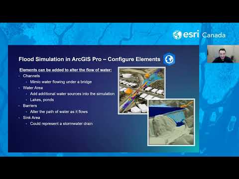
In this webinar, we’ll explore practical workflows for visualizing flood data and creating interactive maps that illustrate potential flood extents and impacts. You’ll learn how ArcGIS Solutions can a
Watch Video
How to remove the external borders of a polygon feature class without losing the interior borders in ArcGIS Pro.
Watch Video
In these Canadian courses, learn how to infuse your geographic information system (GIS) projects with geospatial artificial intelligence (GeoAI).
View
Learn how to customize the design elements within ArcGIS Experience Builder to personalize themes for a better user experience.
Watch Video
Learn how to efficiently update multiple features at once with Batch Editing in ArcGIS Experience Builder. Save time and improve data accuracy in your web maps.
Watch Video
Loading More...