Get job-ready for a career in GIS with Durham College’s new program
Durham College’s GIS for Data Analytics program has its first intake in fall 2026. Learn more about its curriculum, teaching philosophy and structure.
View
Durham College’s GIS for Data Analytics program has its first intake in fall 2026. Learn more about its curriculum, teaching philosophy and structure.
View
Calgary Airports has drastically improved its emergency response times with the help of geographic information systems (GIS), which enable airport staff to rapidly route responders to emergencies.
Watch Video
Ready to transform your field workflows? Discover the new task features in ArcGIS Field Maps that let you create, assign, and track work in one app. Learn how to configure smart forms, automate action
Watch Video
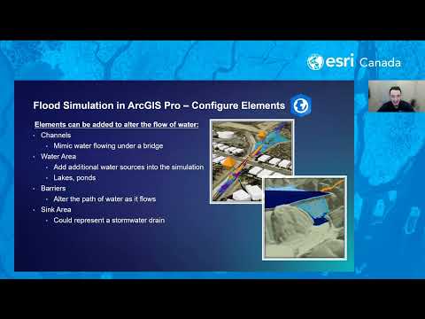
In this webinar, we’ll explore practical workflows for visualizing flood data and creating interactive maps that illustrate potential flood extents and impacts. You’ll learn how ArcGIS Solutions can a
Watch Video
The Esri Canada Federal GIS Conference returns in 2026. Join us to connect with your colleagues in federal government who are using the geographic approach to improve life for all Canadians.
Watch Video
Join us to explore the vision, features, benefits, and demonstrations of new capabilities in Trimble Unity Permit (formerly Cityworks PLL) and the new Trimble Unity Field mobile app, migration to the
Watch Video
Discover the latest GIS updates in imagery, ArcGIS Indoors and ArcGIS Field Maps. Stay apprised of new tools and smarter workflows with this edition of Getting Technical.
Watch Video
Explore Halifax Regional Municipality’s award-winning approach to applying geographic information system (GIS) technology—from traditional mapping services to outcome-driven solutions.
Watch Video
Get ready to dive into ArcGIS Survey123! In this webinar, we’ll show you how to build and customize surveys using both the web designer and Survey123 Connect. With live demos and practical tips, you’l
Watch Video
The Region of Peel's Decision Support System (DSS) is optimizing water and wastewater infrastructure management and enabling efficient annual planning using data analysis and Esri technology.
Watch Video
Learn how to easily document your telecom network with ArcGIS Online using the Communications Data Management solution for ArcGIS. We'll show how to extend network access using ArcGIS Field Maps and g
Watch Video
Join us to explore the vision, features, benefits, and demonstrations of new capabilities in Trimble Unity Maintain (formerly Cityworks AMS) and the new Trimble Unity Field mobile app, migration to th
Watch Video
The City of Kelowna manages over $7.8 billion worth of infrastructure. See how it moved from managing asset data in scattered spreadsheets to a single source of truth powered by Trimble Cityworks.
Watch Video
ERAC uses GIS to locate resources, streamline data collection and manage response team quality across Canada, enabling them to enhance emergency response for dangerous goods incidents.
Watch Video
See how ArcGIS Survey123 with AI assistant speeds up field reporting. Auto-build forms and extract insights from photos in this 24-second demo.
Watch Video
Learn how ArcGIS enhances data-driven decisions, improves asset information and network modeling for water utilities. Join this webinar, co-presented with Aquanuity, to see how AquaTwin extends ArcGIS
Watch Video
In today’s GeoSnap, we’ll explore how to estimate the monthly storage credit usage for each item in ArcGIS Online.
Watch Video
The City of Barrie, Ontario's Plow Tracker app uses ArcGIS Online to deliver real-time winter road service updates, enhancing maintenance efficiency and public communication through GIS technology.
Watch Video
The GIS Playbook for Local Government Leaders features 70+ ideas for solving municipal, county-level and regional issues using a geographic approach.
View
Discover Canadian flood and drought data that will help you better understand and address climate whiplash events in Canada.
View
Loading More...