Esri Canada named a Municipal Changemaker by Municipal World
Geographic information system (GIS) provider recognized for helping Canadian municipalities become smarter using location intelligence.
View
Geographic information system (GIS) provider recognized for helping Canadian municipalities become smarter using location intelligence.
View
Dana McKee spotlights the City of St. Albert, Alberta, emphasizing its contributions to the Community Map of Canada, showcasing how the city uses trusted data and mapping tools to benefit residents.
Watch Video
Watch Video
What does "smart" truly look like in public works operations for mid-sized Canadian municipalities? How to deliver big, on medium-sized budgets.
View
Discover how Fathom Studio blends geographic information systems (GIS) and artificial intelligence (AI) to power better planning, improve decision‑making and shape the future of community design.
Watch Video
Discover how public works departments across Canada are using GIS.
Read moreCanadian firm transforms work zone safety with AI and GIS, helping cities boost road safety, ease congestion and improve permit compliance.
View
See how the City of Grand Forks modernized its Official Community Plan by transforming a static PDF into an accessible digital experience using ArcGIS StoryMaps.
View
Learn how streamlined parcel data integration empowers municipalities to keep mapping accurate, current and easy to manage.
View
The City of Kelowna manages over $7.8 billion worth of infrastructure. See how it moved from managing asset data in scattered spreadsheets to a single source of truth powered by Trimble Cityworks.
Watch Video
This technical blog post explores two ArcGIS Pro imagery workflows to identify built environment gain and loss across two time periods.
View
Quickly gather and manage public feedback using Instant Apps. Boost engagement and streamline your data collection process.
View
Explore Halifax Regional Municipality’s award-winning approach to applying geographic information system (GIS) technology—from traditional mapping services to outcome-driven solutions.
Watch Video
Manage public feedback using the Manager Instant App. Provide an easy to use solution for your data reviewer to engage with.
View
Stay ahead of the forecast with the Weather Engine app, created by Huntsville and Lake of Bays using the Community Map of Canada for real-time local weather conditions. Margaret Stead
Watch Video
How to optimize water utility operations using GIS in Canada.
DiscoverStay ahead of the forecast with the Weather Engine app, created by Huntsville and Lake of Bays using the Community Map of Canada for real-time local weather conditions. Weather Engine
Watch Video
Julie Rokoratu spotlights the Regional County Municipality of Nicolet-Yamaska in Québec and their contributions to the Community Map of Canada.
Watch Video
“Lead with location” playbook features 12 Canadian examples on how to boost field operations using geographic information systems.
View
How geospatial tools help Canadian communities reduce wildfire risk, especially in the WUI, before flames arrive.
View
The City of Windsor created an engaging and informative StoryMap that was used to deliver a presentation in a unique and captivating way.
View
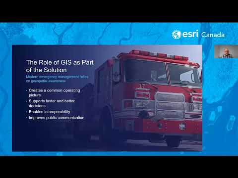
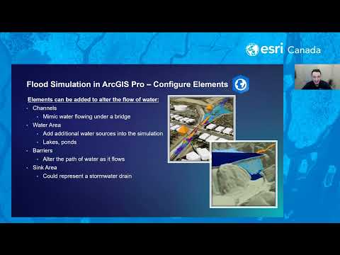
In this webinar, we’ll explore practical workflows for visualizing flood data and creating interactive maps that illustrate potential flood extents and impacts. You’ll learn how ArcGIS Solutions can a
Watch Video
Loading More...