How use cases can help you implement your GIS strategy
You’ve defined a strategic roadmap for GIS at your organization; now it’s time to implement. But it can be daunting to try to translate strategic goals into discrete activities. In this blog post from Esri Canada management consultant Darren Sutton, discover how use cases can help you drive your GIS strategy with clear, goal-oriented activities.
In the Management Consulting practice at Esri Canada, we help customers identify their geospatial needs and form strategic plans to help achieve them. Using tools like the Geospatial Strategy on a Page, we have worked with public and private sector organizations to define visions, goals, strategies and implementation roadmaps aimed at maximizing GIS investments. Once the roadmap has been defined, the next step is to implement the strategy. Implementation requires knowledge, partnerships, organizational influence, funding and investment. It’s a complex ask, but with the right tools, you can link your strategic objectives to well-defined implementation activities.
Implementing a GIS strategy has never been more complex or broader in scope. Consider the range of applications represented in Esri’s Essential GIS Patterns of Use:
- Mapping and visualization
- Data management
- Field mobility
- Monitoring
- Analytics
- Design and planning
- Decision support
- Constituent engagement
- Sharing and collaboration
Regardless of the size or focus of your organization, you can probably identify examples of activities that fall into some or all of these patterns of use. But can you describe how your strategy will enable more capabilities? This is an exercise of its own, for which particular tools are needed. There are a variety of tools available, including Esri’s own Geospatial Solution Canvas. In this blog post, I’ll take you through a common tool that you can use when implementing your geospatial strategy: the use case.
A use case is a simple representation of someone’s interaction with a solution. We call these people “actors”. Use cases are versatile because they describe these interactions in plain language. But they can also be combined to illustrate a complex set of interactions among multiple actors and solutions (often represented as a use case diagram).
The simplest version of a use case has both explanatory power and visual simplicity, like the following example.
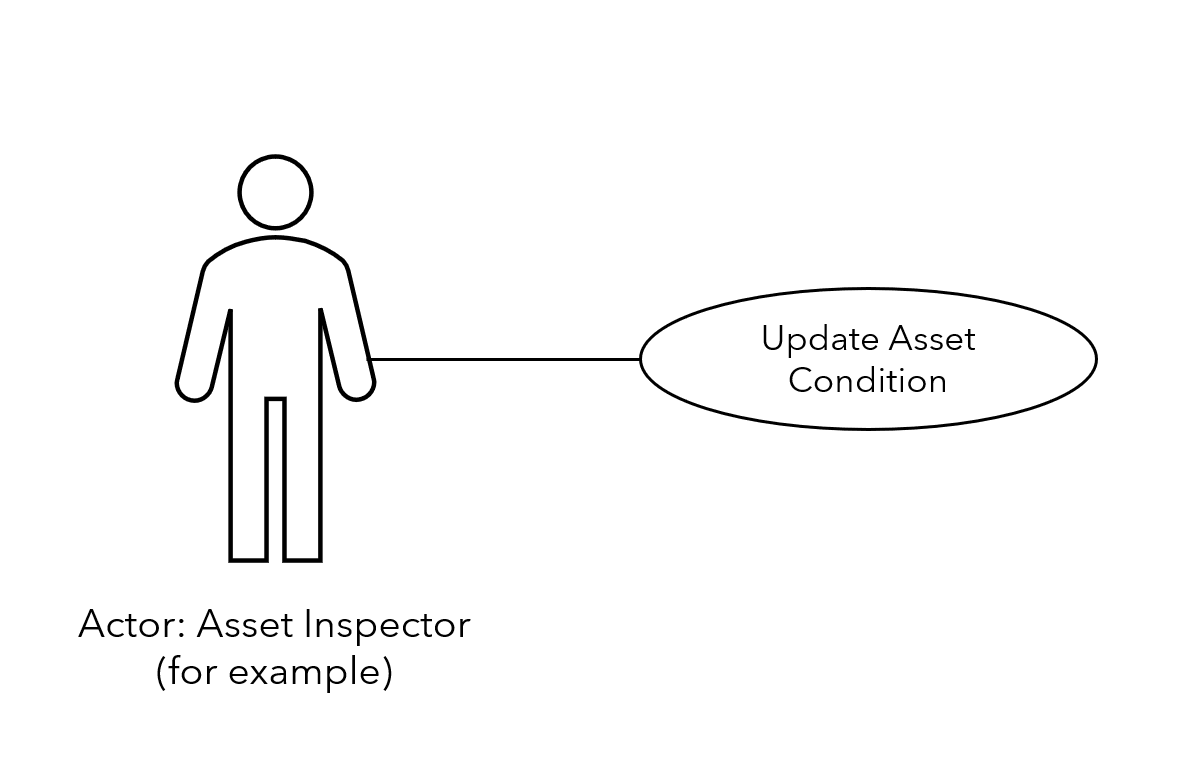
Figure 1: Example Use Case
Organizations can easily define use cases for their geospatial patterns of use. For example, consider an asset inspector who captures the location of a newly installed “Yield” sign to update their organization’s asset management system. This is an example of a field mobility use case and could be summarized as follows:
| Actor | Use case | Pattern of use |
|---|---|---|
| Asset inspector, Transportation and Roads Department | Capture the location of a new asset | Field mobility: this use case occurs in the field |
Elaborating the sequence of use cases helps us to add more details. For example, what does the asset inspector do next?
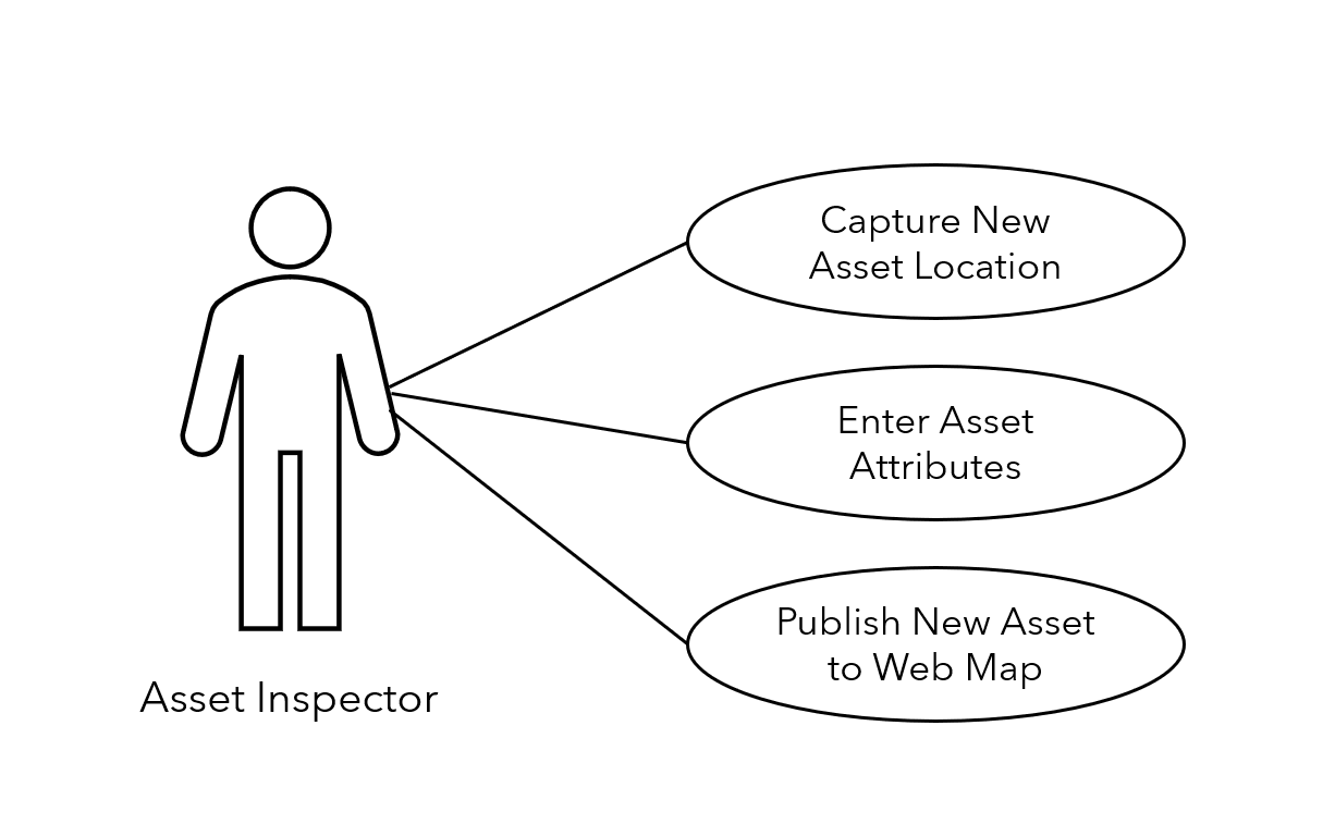
Figure 2: Example of Multiple Use Cases
The flow of work turns out to involve three different geospatial patterns of use.
| Actor | Use case | Patterns of use |
|---|---|---|
| Asset inspector, Transportation and Roads Department | Capture the location of a new asset | Field mobility |
| Enter the new asset’s attributes (material, manufacturer, asset number) | Data and data management | |
| Publish the new asset to a web map | Mapping and visualization |
This simple elaboration on geospatial applications can lead to a diverse set of use cases. But then what? That’s where the true power of use cases lies.
Let’s apply the previous exercise to geospatial solutions that we haven’t implemented yet. For instance, suppose our asset inspections are done manually in the field and are only published when the inspector returns to the office. How would we determine what capabilities a mobile geospatial application would need to replace the current process? Simple: start with the use cases.
Use cases are leveraged for many purposes in geospatial projects, such as:
- defining project scope,
- determining requirements,
- specifying user stories or solution specifications,
- guiding test case development, and
- evaluating if solutions are fit for purpose.
Use cases form a bridge between strategic planning and implementation. You can use them to plan the actions required to achieve your strategic aims. Begin with the highest priority implementation roadmap items. What use cases will be enabled? Using our process for asset inspection, GIS staff, managers and project personnel can expand each roadmap initiative into a set of use cases. The first pass won’t yield a complete set, but that’s fine. You’re looking for a place to begin drafting project charters and operational plans for your strategy.
Geospatial use cases are unique in their combination of simplicity and power and can be an invaluable tool for organizations implementing geospatial strategic plans. Think of the value in describing a strategic goal and then illustrating a direct linkage down to a use case that will be enabled by your strategy. Moreover, as projects are delivered, you can leverage use cases to evaluate how your solutions met the intended goals. This provides you with an easy way to check whether the intended benefits were obtained.
Try leveraging use cases in your own geospatial strategy process. They’re a great tool for helping any organization achieve its strategic goals.
Feel free to reach out if you need support in developing your use cases. We’re here to help!
Want to add more geospatial strategy tips to your toolbox? Sign up for our newsletter, The Geospatial Edge, to get a fresh batch of geospatial strategy resources delivered right to your inbox once per quarter. Simply visit our Preference Centre and select “GIS Strategy” from the available options.