Connecting Northern Ontario: Broadband, GIS and Knowledge Preservation
Faster broadband, better access to education and preserved infrastructure knowledge are transforming Northern Ontario communities through Blue Sky Net’s GIS initiatives.
Northern Ontario is known for its vast landscapes and tight-knit communities. However, for years, limited broadband infrastructure in rural areas hindered both economic growth and access to essential services. Small municipalities face additional challenges: staff often lack the expertise to leverage geospatial data and critical historical knowledge about infrastructure. This means broadband projects risk being lost as long-serving staff retire.
For Blue Sky Net (BSN), a North Bay-based telecommunications non-profit, these challenges were an opportunity to innovate. Since 2002, under the leadership of Executive Director Susan Church, BSN has worked with municipalities across Northern Ontario to strengthen communities, support economic growth and preserve institutional knowledge.
"When I think back to those early days, the critical speed we were trying to achieve with all these funding programs was a blistering three megabits per second down and one up. I still have all these folders in my filing cabinet with applications. It was like, I sure hope we can reach that speed."
~ Susan Church, Executive Director, Blue Sky Net
From pushpins to GIS solutions
Initially, BSN tracked broadband projects with pushpins on paper maps. Each pin represented a tower, speed or coverage area. This method was time-consuming, hard to update and difficult to share. Recognizing the need for a better approach, BSN turned to Esri geographic information system (GIS) solutions in 2015 and launched Connected North to digitally map broadband infrastructure for public use.
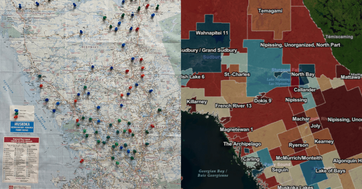
Blue Sky Net replaced pushpins on paper maps with the Ontario Internet Access Map. BSN uses ArcGIS Online and ArcGIS Pro to document the expansion of broadband access across Northern Ontario.
GIS technology quickly became the backbone of BSN’s operations. With tools like ArcGIS Pro, ArcGIS Online, ArcGIS Experience Builder, ArcGIS StoryMaps and the Ontario Broadband Resource Hub, the team could visualize broadband availability down to the neighbourhood level, identify gaps and provide data-driven recommendations to municipalities and funding agencies.
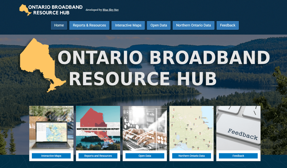
The Ontario Broadband Resource Hub centralizes data on broadband coverage, helping municipalities, service providers, funding agencies and the public to plan for the expansion of internet access.
BSN combined national broadband datasets, MPAC parcel information and municipal records to analyze connectivity gaps, especially in rural and Indigenous communities where detailed information is often scarce. By doing so, they created a comprehensive resource for broadband planning, helping internet service providers and government agencies prioritize investments.
Tangible results across the region
The results have been significant:
-
- Expanded connectivity: Broadband coverage now reaches more households, reducing the digital divide between Northern and Southern Ontario.
- Streamlined operations: Municipal staff can access infrastructure maps and historical data quickly, supporting housing permits, zoning changes and other projects.
- Knowledge preservation: Decades of infrastructure knowledge, once trapped in filing cabinets and the minds of retiring staff, is now digitized and accessible.
"ArcGIS software has transformed the way we track and share data on broadband expansion. Moving from pushpins on a paper map to online with the Ontario Internet Access Map has provided easy access to data for everyone, from government officials to the general public. The online maps let you easily explore and search for any location to see broadband information across Ontario."
~ Rebecca Snider, GIS Coordinator, Blue Sky Net
Broader benefits
The integration of GIS has unlocked multiple benefits:
-
- Economic growth: Reliable broadband supports local businesses, enables remote work and helps retain young talent in rural communities.
- Improved services: Residents gain easier access to education, healthcare and government resources.
- Scalable models: BSN’s approach serves as a template for other regions looking to combine GIS and broadband planning.
Susan highlights the broader impact: "In order to grow the economy and compete globally, we had to be able to reach people globally. GIS allows us to tell the story of Northern Ontario’s connectivity and help funders, policymakers and communities understand where the needs are."
BSN also places a strong emphasis on training and community engagement, ensuring municipalities without GIS experience can use the tools effectively. For example, small municipal staff often juggle multiple roles and BSN’s hands-on support allows them to harness geospatial data for everyday decision-making.
Looking forward
BSN’s future plans aim to further enhance connectivity and data capabilities:
-
- Highlight the need to expand broadband to more remote and underserved areas.
- Refine GIS tools for advanced data analysis and visualization.
- Strengthen partnerships with Indigenous communities, supporting infrastructure planning and digital inclusion.
Susan proudly shares how transformative this work has become, “We have just facilitated the building of six Broadband-new network projects across Northern Ontario (with more to come) and I can tell you it could not have happened without our Esri ArcGIS integration.”
By combining broadband initiatives with GIS technology and knowledge preservation, Blue Sky Net demonstrates that small organizations can make a big impact bridging the digital divide and driving socio-economic growth in Northern Ontario.
 Video: GIS for Expanding Broadband Internet 1-minute video demonstrating how Blue Sky Net uses geospatial technology.
Questions? Contact us at esri.ca/telecommunications
Learn how telecoms strengthen coverage and connectivity with GIS. Feel free to connect directly with Sergio Palladini, Industry Manager, Telecommunications.-
Let’s hear your story!-
Have you used GIS or a partner solution to solve a challenge or improve your organization? We would love to showcase your success and inspire others. Share your experience and contribute to industry knowledge with a GIS Success Story.