Introducing a New Public Safety Hybrid Basemap Style
The Community Map of Canada has introduced a powerful new basemap style designed to elevate your emergency mapping workflows. The Public Safety Style with Imagery Transition is built using authoritative Canadian data with seamless imagery integration, offering a high-contrast, context-rich foundation for decision-making when every second counts. By developing this specialized map style, we aim to help build stronger, more resilient communities and empower them to respond effectively to emergencies.
Built for Clarity. Designed for Action.
Through feedback from Public Safety professionals, we identified a common theme: they need a map that’s easy to read, highlights the data that matters most and offers rich detail as you zoom in. In response, the Community Map of Canada team designed a basemap style that combines the clarity of vector data with the detail of high-resolution imagery, delivering the right information at the right scale.
One Web Map, Two Views
In high-pressure situations where every second counts, Public Safety professionals need instant clarity. This style was purpose-built to support fast, informed decision-making when it matters most. It’s ideal for emergency response situations such as wildfires, providing responders with clear, detailed and timely information to make critical decisions quickly. By delivering the situational awareness needed in critical moments, this basemap can help save lives and protect property.
On smaller scales, the map offers a dark, focused view of the world. It brings forward the information that matters most, roads and highways, medical centers, schools, government buildings, community centers, addresses, parcels, and administrative boundaries, while keeping visual clutter to a minimum.
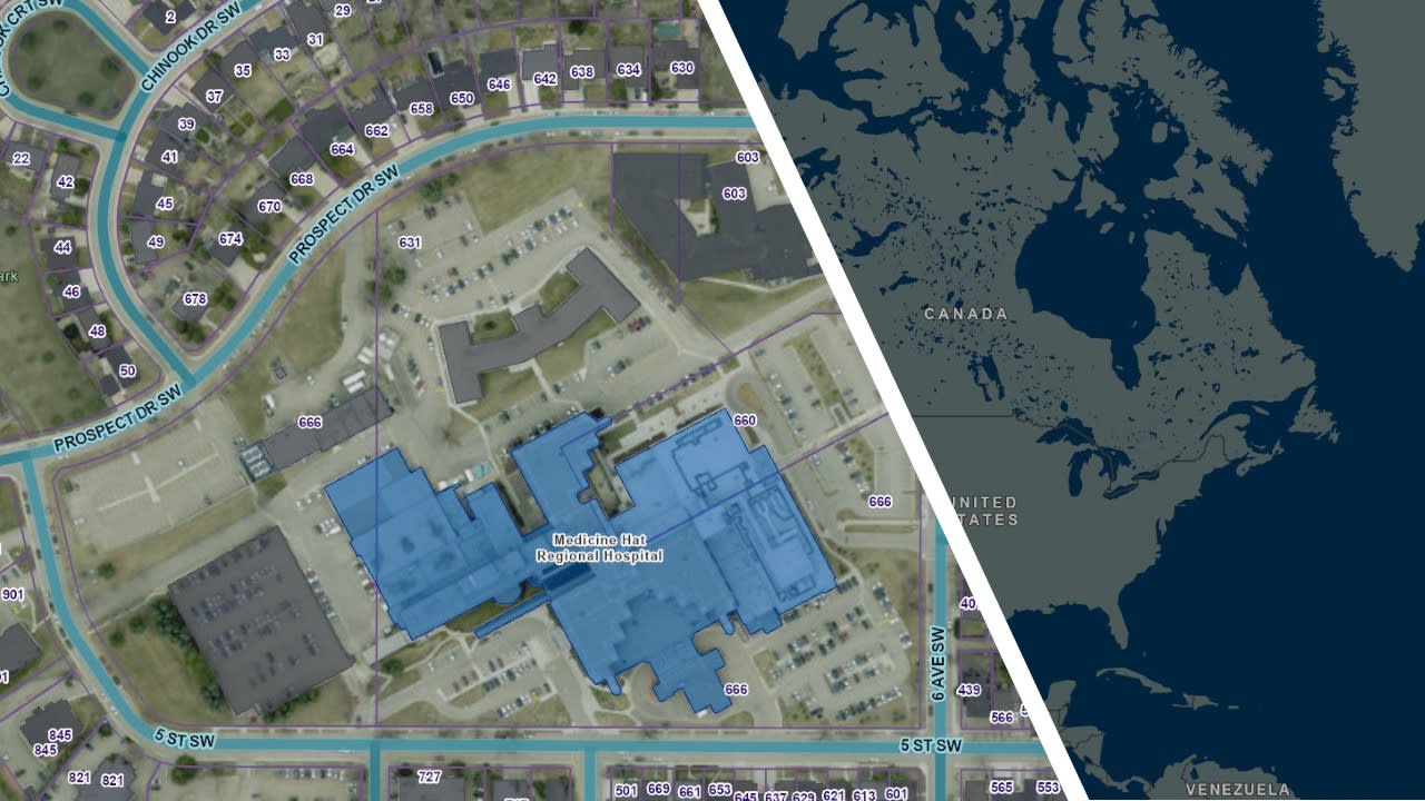
The Public Safety Style shown at both a smaller scale and ground level
When you zoom in, the map seamlessly transitions into World Imagery, revealing high-resolution aerial imagery. That’s where Public Safety teams gain true ground-level awareness, seeing rooftops, access points, vegetation and other critical details that are not visible in standard basemaps. The goal was to avoid switching basemaps or losing context. By integrating everything into a single basemap, users can navigate across all scales while preserving continuity and clarity.
Why a Dark Background?
The dark theme isn’t just for style, it’s intentional - emergency responders often operate at night or in low-light conditions. Dark basemaps also reduce screen glare and improve visibility of overlaid data such as incident locations, road networks and infrastructure.
Explore the Style
The Public Safety Hybrid Style is now available in the ArcGIS Living Atlas of the World. You can use this specialized basemap in your ArcGIS Online or ArcGIS Enterprise web maps, dashboards or mobile apps.
View the map on the Living Atlas
If your organization would like to contribute data to the Community Map of Canada or learn more about customizing this style for your needs, reach out to our team. We’d love to support you!