From “data about data” to AI fuel: metadata powers ArcGIS intelligence
AI is transforming ArcGIS, and metadata plays a key role in making that transformation possible. This blog post explains why metadata is essential to the ArcGIS AI platform and how strong, well-structured metadata makes your content both human-friendly and machine-readable. It also offers practical starting points to help you improve the quality, clarity and usability of your ArcGIS item metadata.
Everyone has heard the definition: metadata is “data about data.” But in practice, metadata is far richer and far more powerful than that phrase suggests. Metadata describes what a dataset represents, how it was created, who created it, when it was last updated and how it should be used. Good metadata helps users discover, understand and trust data. It allows people to compare datasets, assess fitness for use and confidently select the right item for their needs. In other words, metadata ensures your content is FAIR: Findable, Accessible, Interoperable and Reusable.
Metadata is now critical in the age of AI
As ArcGIS is increasingly becoming a Geospatial Artificial Intelligence (AI) platform, metadata is no longer just a documentation best practice, but it is a technical prerequisite. Generative AI in ArcGIS works through natural language prompts. When a user asks a question, AI translates that prompt into geospatial intent, searches for relevant data and performs analysis using the content it can identify and understand.
Thus, without high-quality metadata, ArcGIS AI-based query platforms such as Data Explorer Instant App and ArcGIS Hub AI Assistant, cannot reliably identify the right dataset, understand what each data field represents or retrieve and analyze data accurately. This explains why metadata today is not just about human FAIR; it’s about AI FAIR, meaning metadata is what makes your data intelligible to both people and machines.
How to get started with metadata
High-quality metadata includes clear item titles and descriptions, meaningful tags, well-defined attribute field aliases and descriptions and correct data types and domains. That's a lot to consider and can quickly become overwhelming. Esri has created a few tools to help you get started with evaluating and improving your content’s metadata.
ArcGIS Living Atlas of the World Evaluate & Nominate App
The Living Atlas of the World is where you can find a curated collection ready-to-use layers, maps and apps to support your GIS workflows. The Living Atlas content is fully integrated across the ArcGIS platform and therefore it meets best practices in visualizations, analysis and metadata documentation.
The new “Evaluate & Nominate” app helps you review your metadata and gives you suggestions on where you can improve. The app looks at key metadata elements of your item and gives them a score along with guidance about how to improve your item’s score.
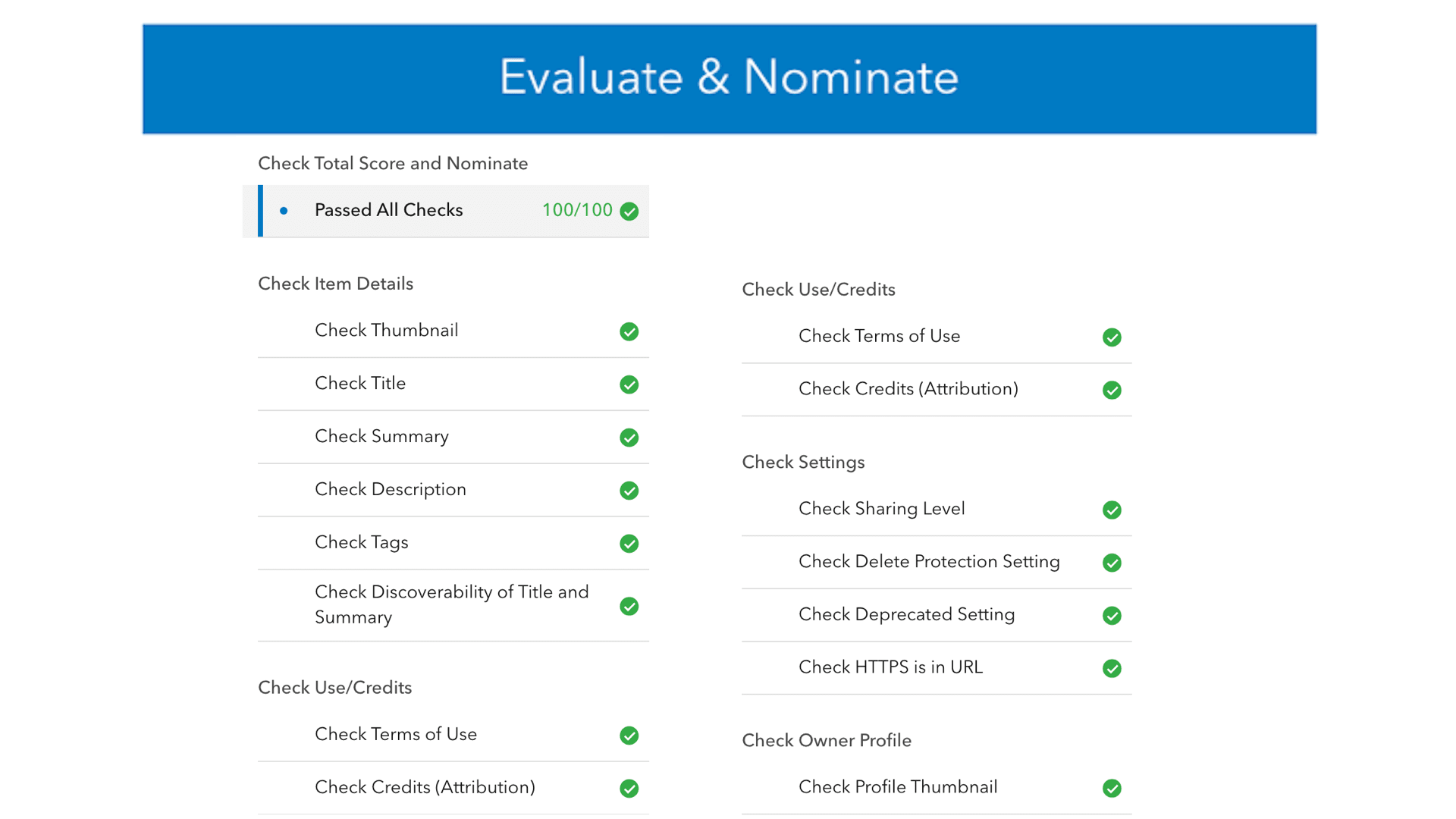
Evaluate & Nominate-App
For additional information on all elements that are evaluated and details on the scoring process check out Living Atlas Resources.
If your organization is a trusted source for layers, maps, dashboards, storymaps or tools, go ahead and nominate an item for inclusion in the Living Atlas.
Item Details Assistant
To further simplify metadata creation and management, Esri introduced the ArcGIS Item Details Assistant to make metadata creation faster, more intuitive and more consistent. The Item Details Assistant leverages generative AI to help users create, complete and enrich metadata directly on the item page. At its core, the assistant accesses and analyzes existing metadata, table schema, geometry, spatial extent and field statistics to generate context-aware recommendations.
The Item Details Assistant is already available as a beta feature in ArcGIS Enterprise 12.0 and is planned for ArcGIS Online in early 2026. Enterprise users can provide their feedback to the Early Adopter Community. For Online users, access to private beta is by invitation only.
Explore the resources below to learn more about metadata in ArcGIS, Item Details Assistant and stay connected with the community!
- Metadata Year in Review for 2025
- Introducing the Item Details assistant (beta)
- Item Details assistant (beta) Early Adopter Community
- Metadata, Catalogs and Search Esri Community
Read Part 2 - From “data about data” to AI fuel: ArcGIS Online Field Metadata Updater - now available