Milton Hydro Connects Field & Office Teams with One Map and Utility Network
As utilities grow, small information gaps can turn into operational blind spots. Learn how Milton Hydro unified network information across the organization to improve system awareness, streamline inspections and deliver more reliable service to customers.

As the Town of Milton continues to grow, Milton Hydro is improving visibility across its network with a shared GIS-based view of the electric system.
Milton Hydro serves the Town of Milton and the wider surrounding service area, in Ontario, delivering electricity to more than 45,000 customers across one of Canada’s most rapidly expanding communities.
The utility is strengthening planning and service delivery by giving field crews, analysts and leadership a shared view of its electric system across devices with geographic information system (GIS) technology. The same mapping experience expands reporting, inspection and field programs.
Challenge: Growing Fast Exposes Cracks in Visibility
In the early stages of its modernization, Milton Hydro relied on separate tools for viewing, editing and reporting, which limited collaboration. Field crews, GIS editors and engineers had no simple way to share updates or track progress, resulting in leadership lacking real-time visibility into inspections and field activity.
As Milton Hydro grew, mobile reporting and an accurate network model became essential to support more users and expanding programs.
The utility wanted a consistent mapping experience across desktop, mobile and web applications. As inspection and reporting programs expanded, better visibility, coordination and access to trusted information became increasingly important across the organization.
Solution: One Map Builds a Shared System of Truth
At the centre of Milton Hydro's approach is One Map, a unified GIS environment that gives employees access to the same network information regardless of where they work. Built on Esri ArcGIS and supported by ArcGIS Utility Network, it helps field crews, office staff, engineers and leaders work from a common understanding of the system.
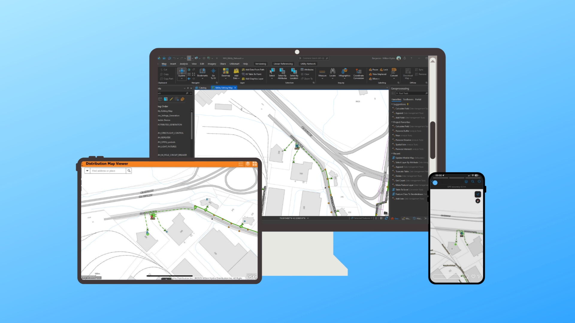
Milton Hydro’s One Map, a unified mapping and decision support tool, gives teams the same view across desktop, mobile and web to keep teams aligned from field to boardroom.
How the solution works
- Field crews capture issues, inspections and photos once and share them instantly with office teams.
- Office staff submit facility issues using the same workflows.
- Leaders track progress and priorities in Esri ArcGIS Dashboards for faster decisions.
- Engineering maintains a consistent system model that supports daily work and future programs.
One Map helps staff locate assets, report issues and access current network information faster, which supports quicker response times and more reliable service for customers.
A key design principle was consistency. Whether staff access GIS from ArcGIS Pro, ArcGIS Field Maps or a web application, they see the same basemap, layers and search experience. This reduces training, builds confidence in the data and makes it easier for teams to collaborate across departments.
Using ArcGIS Field Maps and ArcGIS Survey123, field staff capture issues, inspections and photos that are immediately available to office teams for reporting and follow-up.
To support One Map, Milton Hydro uses custom basemaps and shared layer files to keep symbology, labels, popups and search behaviour consistent across applications. Users can move between desktop, mobile and web workflows while accessing the same network information.
Custom basemaps show public and private parcels, roads, buildings, water features and greenspace. Shared layer files ensure symbology, labels, popups, scale ranges and search behaviour remain consistent, helping teams collaborate more easily across departments.
“Utility Network has become the way Milton Hydro keeps field crews, operations and leadership aligned. When everyone starts from the same map, decisions become much clearer.”
~ Ben Taunton, Professional GIS Applications Specialist, Milton Hydro
Results: Turning information into action
Field reports and photos flow directly into the GIS, reducing rework and improving data quality. Real-time dashboards provide visibility into inspections and operational programs, while Utility Network helps teams better understand asset relationships, assess impacts and support planning.
Building on this foundation, Milton Hydro continues to improve how information is managed and shared across the organization. Since presenting this work at the 2025 Esri Canada User Conference, Ben Taunton has used AI to fully automate the data update process for Milton Hydro's Asset Overview dashboard. The dashboard provides a high-level view of key network assets, helping staff track infrastructure metrics and maintain access to current information while reducing the manual effort previously required to update reports.
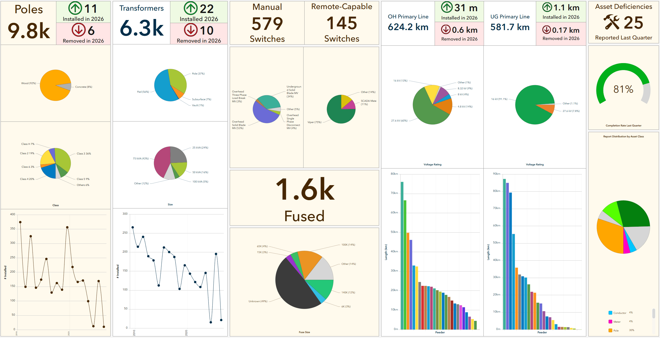
Milton Hydro's Asset Overview dashboard helps translate complex asset data into actionable information for planning, maintenance and investment discussions.
Business outcomes
-
- Faster, clearer decisions: Leadership sees inspection status and network conditions in real time, enabling quicker prioritization and fewer handoffs.
- Safer, more consistent operations: Shared map context and standardized inspections cut miscommunication and support trace aware planning with Utility Network.
- Less rework and fewer operational inefficiencies: Field reports and photos are directly routed into the platform, while consistent symbology and search help reduce duplicate effort across teams.
“We are seeing many Canadian utilities focus on system modernization to improve data and data access to support better customer service and safety. Milton Hydro shows how reducing data silos and relying on GIS as a foundation for their connected assets can support effective and efficient collaboration and decision making. Their approach is a practical model that leverages mapping to unify communications.”
~ Armando LaCivita, Director, Utilities, Esri Canada
Lessons for utility leaders
Milton Hydro's experience shows that GIS modernization is not just about deploying new technology. By creating a consistent experience across desktop, mobile and web applications, the utility established a foundation that can support new workflows, inspection programs and business needs over time. Rather than building standalone solutions for individual departments, Milton Hydro developed a scalable approach that can evolve alongside the organization.
Laying the groundwork for smarter utility management
With a modern GIS foundation in place, Milton Hydro is well positioned to expand inspection programs, automate workflows and explore new capabilities as operational needs evolve. By connecting field, office and leadership teams through shared information, the utility has created a platform that supports both day-to-day operations and long-term modernization.
Learn more
esri.ca/electric Esri Canada Electric Utilities
Milton Hydro presentation at the Esri Canada User Conference 2025
Let’s share your story!
Have you used ArcGIS or a partner solution to solve a challenge or improve your organization? We would love to showcase your success and inspire others. Share your experience and contribute to industry knowledge with a GIS Success Story.